Banchor, Banchory and Boleskine: The wattle-built churches of northern Pictland?
Recently I’ve been pondering the significance of the medieval place-name Banchor, which appears numerous times across Scotland (and the Celtic-speaking countries more broadly), and whose meaning has long been the subject of debate.
The debate has two camps. One sees ‘banchor’ as a Gaelic name, meaning something like ‘horn-cast’ or ‘collection of peaks’. The other sees it as Brittonic – i.e. belonging to the family that includes Welsh, Cornish and Breton, as well as the lost Pictish language – with a rather more prosaic meaning of ‘wattle fence’.
After a lot of research I find myself firmly in the latter camp, and in this blog I want to explain why – and why I think the ‘wattle fence’ interpretation could be significant.
Banchor, Nairnshire: a location suggestive of early Christian activity
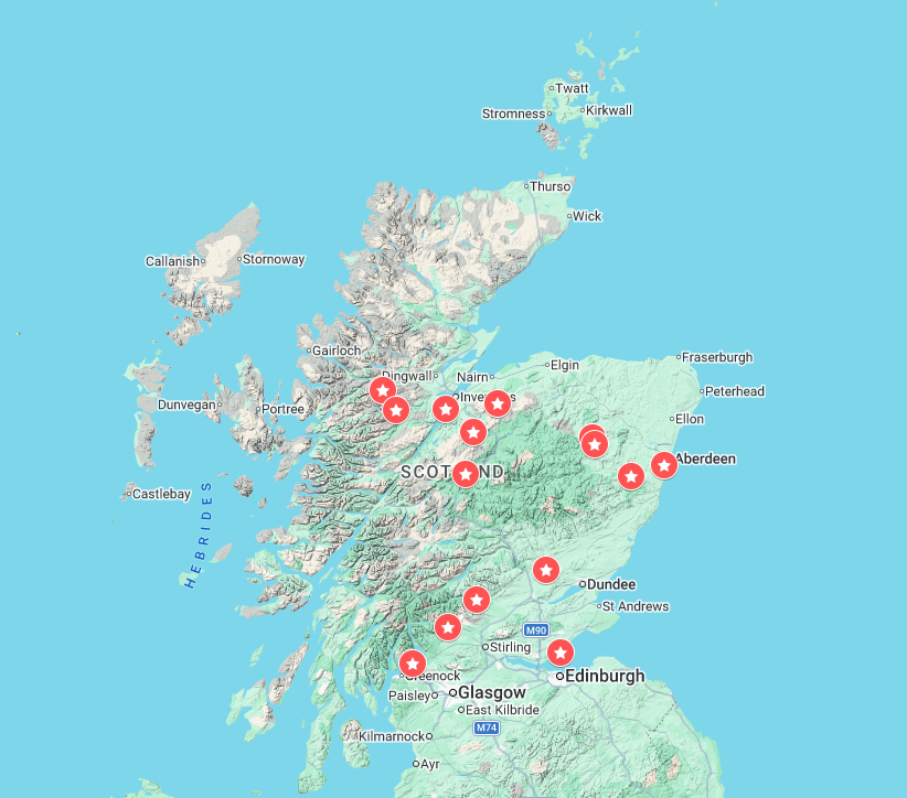
But first I should explain my interest in the name. One of the 15 or so banchor places in Scotland is on the north bank of the River Findhorn at NH 91197 40682, in rural Nairnshire. That puts it in my PhD study area – and in an area with several tantalising hints of early Christian activity.
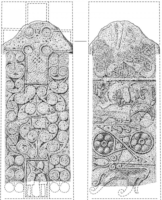
Less than 1 km downriver from Banchor is the Class II Pictish cross-slab known as the Princess Stone, with its enigmatic figures embracing – or wrestling – in the shaft of the cross; an equally enigmatic hooded crossbowman crouching on the reverse, his quarry long eroded away; and two sets of Pictish symbols: a smaller pair comprising a Pictish beast and crescent and V-rod, and a larger pair comprising a double-disc and Z-rod and another Pictish beast.
The Princess Stone may not have been the only early medieval sculpture in the area. In his 1900 book The Natural History of a Highland Parish: Ardclach, Nairnshire, Robert Thomson, minister of Ardclach, wrote that:
A large boulder, called the Priest’s Stone, bearing the figure of a basso relievo cross, is said to have been covered over by the workmen, about seventy years ago, when repairing the present county road leading down the brae to [Ardclach] parish church.[1]
The Priest’s Stone would have stood about 1 km downriver from the Princess Stone, and about 2 km from Banchor. Two stones carved with a cross in the same area hints at the presence of an early church, and this is compounded by the presence, another half-kilometre or so downriver from the lost Priest’s Stone, of a cluster of ‘Logie’ place-names: Logie farm, Logie Wood and Logie Bridge.
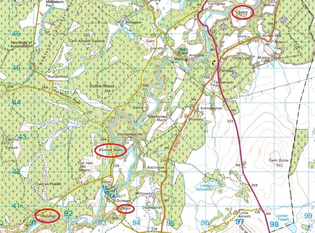
That’s interesting because in 2010, Professor Thomas Clancy identified some instances of the place-name Logie as deriving from Latin locus, meaning ‘(holy) place’, indicating an early church.[2] Although the name sometimes derives from Gaelic lag or lagan, meaning ‘hollow’, a Logie in the vicinity of a Class II cross-slab warrants consideration as a possible locus name.
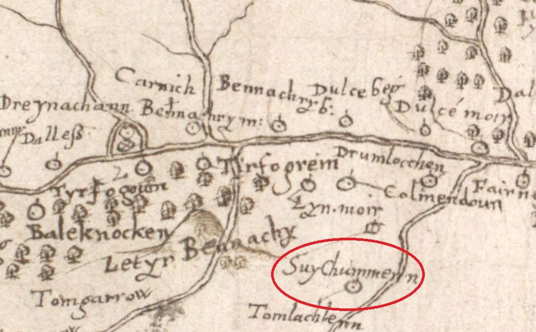
On the slopes of the hillfort of Dunearn, meanwhile, between Banchor and the Princess Stone, is a site identified on the first Ordnance Survey map of 1871 as that of a lost chapel, standing in a grassy area called Chapel Field.
A much earlier map, made c.1590 by Timothy Pont, gives this same spot the name Suy Chummenn, or ‘Cumméne’s Seat’, seemingly a reference to Cumméne Find (d. 669), the seventh abbot of Iona, who may or may not have been culted in this area.
There are lots of hints of early ecclesiastical activity along this 2.5km stretch of the Findhorn, in other words – and that’s what first got me interested in the place-name Banchor.
Banchor-places and the early church
Because regardless of what it actually means, the place-name seems to co-locate very strongly with early churches and monasteries. The best-known are Bangor in Co. Down, Ireland, a monastery founded in 558 by St Comgall, and two in Wales: Bangor in Caernarfonshire, founded in the early sixth century by St Deiniol, and Bangor-is-Coed (Bangor-on-Dee) in Flintshire, founded c.560 by St Dunod.
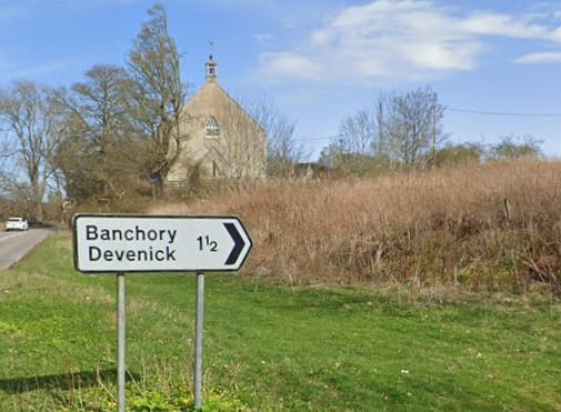
In Scotland, the best-known banchor places are on Deeside: Banchory-Ternan is named for a Pictish saint called Torannán, and Banchory-Devenick for an obscure saint called Devenic or Demhan. Both would appear to be early church foundations.
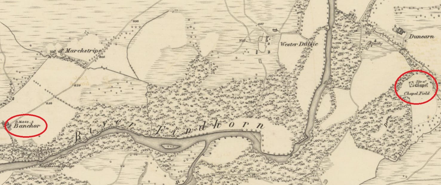
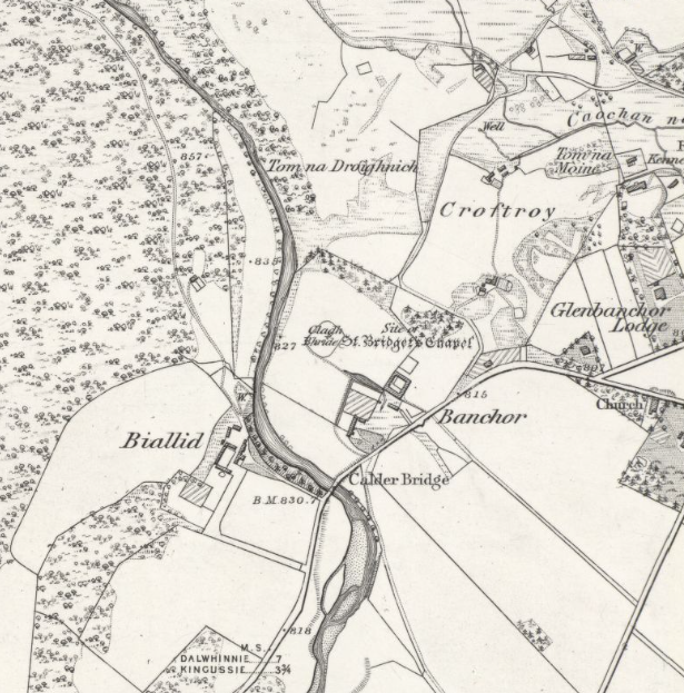
But there are others: near the confluence of the Calder and the Spey south of Newtonmore, Banchor Mains (NN 70659 98803) lies immediately adjacent to the site of a chapel dedicated to St Brigid marked on the first edition OS maps.

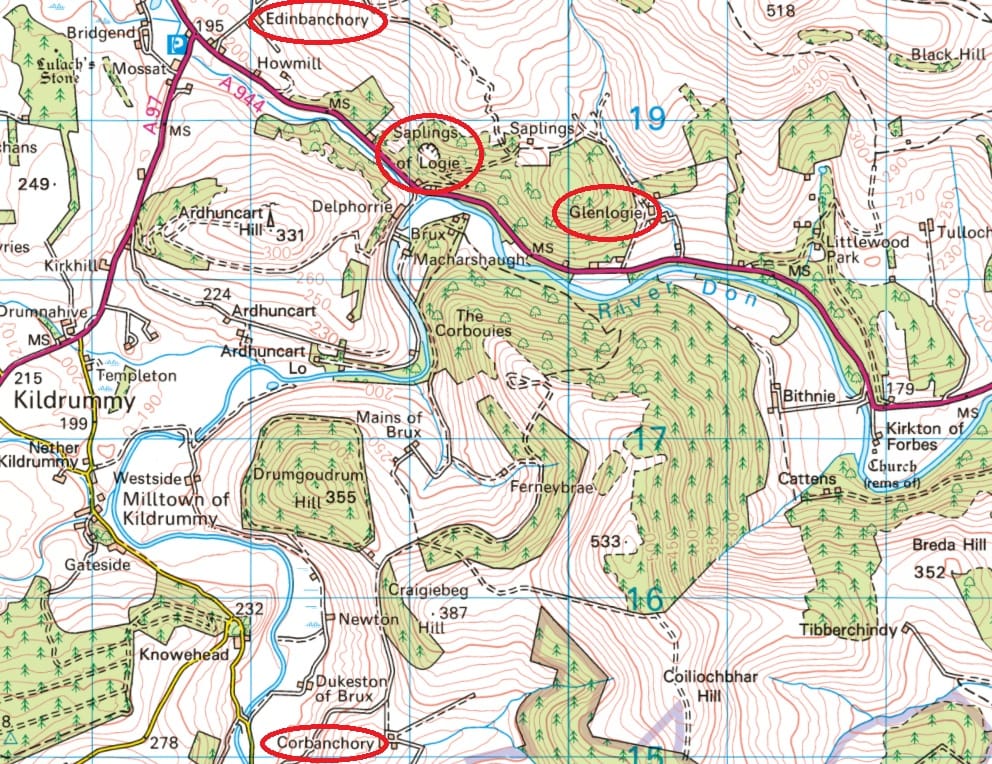
In Strathdearn on the upper Findhorn, another farm named Banchor sits immediately opposite the ancient church of St Fergus at Dalarossie (NH 76269 23981). And in upper Donside, Edinbanchory (NJ 48156 19618) and Corbanchory (NJ 48846 15079) lie a mile or so north and south respectively of the church of St Bride (Brigid again) at Kildrummy.[3]
South of the Mounth, however, the connection between banchor places and the early church isn’t nearly as obvious—and may not even exist. Banchory on the Isla in Angus (NO 19707 40773) has no associated church site, as far as I’m aware, and neither does Tullybannocher on the Earn in Perthshire (NN 75836 21949), Banchory in Kinghorn parish in Fife (NT 26145 88325), or Bannachra near Loch Lomond in Dunbartonshire (NS 34398 84257).
The three remaining ‘banchors’ are lochs: Loch Vennachar in Stirlingshire, Loch Beanncharáin (‘loch of the little banchor’) in Glen Strathfarrar, Inverness-shire, and the identically-named Loch Beanncharáin at the head of Strathconon in Easter Ross. None has an associated early church site.
An Early Gaelic root for banchor?
Since not every banchor place is connected to an early church, toponymists (place-name specialists) have often been reluctant to interpret the name as having ecclesiastical overtones. Instead, as we’ll see, they’ve tended to look to the landscape settings of banchor places for clues to its meaning.
Crucially, since the most famous of the banchors is Bangor in Ireland – and presumably because the consonant cluster in the middle is the very Gaelic-sounding ‘ch’ (although notably not at Bangor itself) – toponymists have tended to favour an Early Gaelic root for the name.
In the Early Gaelic interpretation, the name is formed of two elements. The first is benn, meaning ‘peak’ or ‘point’, with secondary meanings of ‘horn’ and ‘prong’ – essentially something pointy. The second is cor, a noun formed from the verb fo-ceird, whose meanings include ‘puts in place’, ‘sets up’, ‘throws’, ‘casts’ (as in ‘casts aside’) and ‘sheds’ (as in ‘sheds a tear’).
So the verbal noun cor could be understood as ‘the placing/throwing/shedding’ of something. In the case of banchor, the thing in question is the benn: a horn, prong or peak.
A horn-shaped river bend?
In the early medieval Irish tale Táin Bo Fraích (The Cattle-Raid of Fraích), Bangor in Co. Down is said to have got its name because the hero Fraích’s cattle shed their horns on the strand there.
While this is pure dindsenchas (place-name-based folklore), the idea of banchor meaning ‘horn-cast’ was taken up by the toponymist W. J. Watson, who saw its use in Scotland as denoting a horn-shaped loch or river bend:[4]
From benn, ‘a horn’, compounded with cor, ‘a cast’, ‘a setting’, comes bennchar, ‘horn-cast’. Dr Joyce considered that in Ireland it is usually applied to places where there is a peaked hill or a collection of peaks. In Scotland it is a favourite term to denote ‘horns’ that are horizontal, especially horned lakes and horned parts of streams.
I will briefly come back to the lochs later, but for now I want to focus on the land-based Scottish banchor-places. Watson observed that they are typically located on horn-shaped river bends:
In Strathdearn is Banchor, where the river forms bends that strikingly resemble a broad brow garnished with two short horns. Another Beannchar is found on Findhorn above Dulsie Bridge. Somewhat similar horn-like bends occur on Don near Corbanchory and Edinbanchory.
At Banchory-Ternan on Dee the river forms two broad sweeping symmetrical horns. The site of the old church of Banchory-Devenick on Dee is at a bend of the river which forms two horns spreading symmetrically from a somewhat narrow forehead.
Banchory on the Isla in Perthshire is at a striking collection of horn-like bends. At Tullybanchor, on the Earn near Comrie, the river shows similar features, and the same is true of Bannachra in Glen Fruin, Dunbartonshire.
He then mentioned a lost banchor on the River Ness, which I’ll come back to later:
Benchar on the Ness is now forgotten: it probably referred to the broad bend below Dochgarroch.
Then, rather perplexingly, given that a house named Banchor had been mapped by the OS since 1871:
Beannchar of Glen Banchor is on the river Calder, near Aviemore, but its exact position is unknown to me.
And finally:
The only instance that is unconnected with water is Banchor[y] near Kinghorn in Fife; here a notable feature is a long narrow outcrop of rock… which in all probability suggested the name.
Problems with the ‘horn-cast’ interpretation
The overall rigour and quality of Watson’s place-name analyses have made his interpretation of banchor very influential.
It was cited, for example, by Simon Taylor and Gilbert Márkus in their masterly five-volume series The Place-Names of Fife. In their discussion of Banchory near Kinghorn, they too tentatively analysed the name as Gaelic benn + cor, noting that:
Watson states that it means ‘horn-cast’, usually in reference to bends in a river, but in this case it may refer to the long, narrow outcrop of rock immediately east of the farm steading.
There are, however, aspects of Watson’s argument that don’t quite work, and which make his interpretations of ‘horn-cast’ and ‘collection of peaks’ somewhat questionable.
First, in his discussion of the two banchors on the Findhorn, he describes only one of them, in Strathdearn, as being on a horn-shaped bend. For the one that initially got my attention, he only notes that:
Another Beannchar is found on the Findhorn above Dulsie Bridge.
And in fact I would struggle to describe this Banchor as being located on a noticeably horn-like bend, or on much of a bend at all.
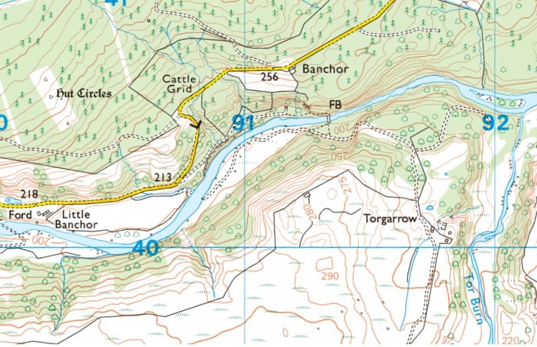
Then there’s his comment that ‘the exact position’ of Banchor on the Calder near Aviemore is ‘unknown’ to him. The Ordnance Survey clearly shows Banchor adjacent to the site of St Bride’s Chapel. While the river is certainly nearby, the meanders in its course here are fairly unremarkable (below). If this site resembles a horn or horns, then so does just about every river bend.
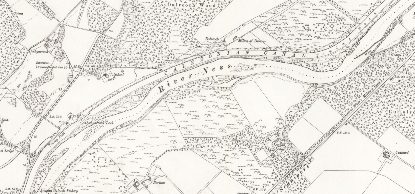
Similarly, he suggests that the lost Benchar on the Ness referred to ‘the broad bend of the river below Dochgarroch’. The river does indeed bend here, but not in a way that seems remarkable enough to inspire a place-name containing benn, whose sense is, after all, ‘pointy’ rather than ‘curved’.
Lastly, there’s Watson’s identification of Banchory in Fife referring not to a river bend, but to a ‘long, narrow outcrop of rock’. Here he interprets the name in what he perceived as its ‘Irish’ sense, where benn refers to vertical peaks, rather than horizontal ‘horns’ in a river. This sits awkwardly alongside the other banchors, and we might wonder why it only appears once in Scotland with this meaning.
A Brittonic rather than Gaelic distribution
It’s awkwardnesses like these that led Taylor and Márkus to identify Banchory in Fife only tentatively as Early Gaelic benn + cor. Indeed, their discussion started with the acknowledgement that:
This is a problematic name.
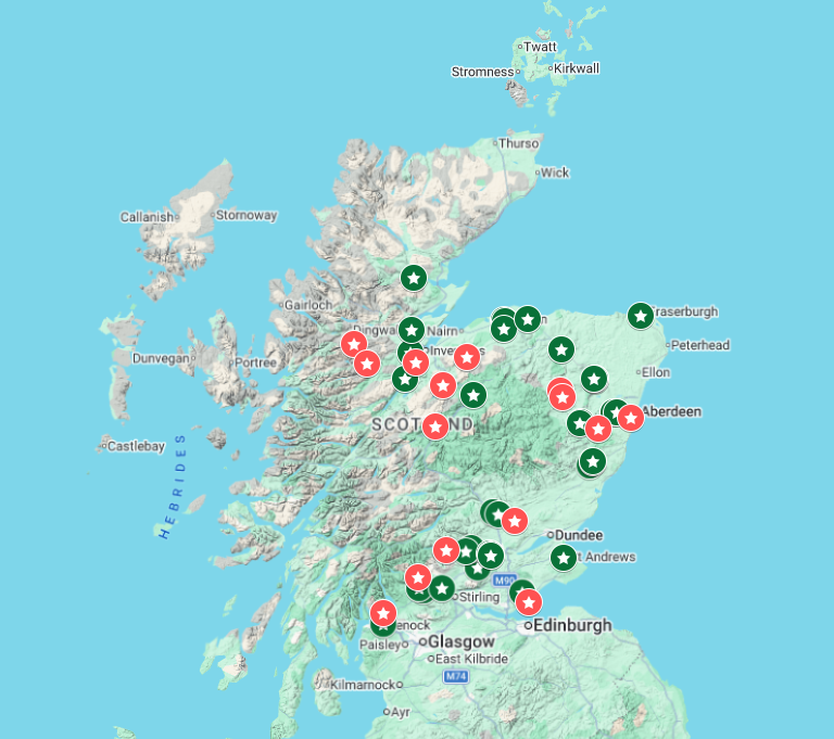
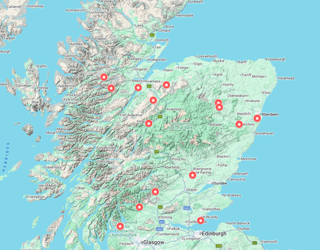
As a supposedly Early Gaelic name, it becomes even more problematic when banchor places are plotted on a map of Scotland. When I mapped the examples listed by Watson, I was surprised to see that not a single banchor occurs in what was the Gaelic-speaking kingdom of Dál Riata (Argyll).
Instead, every instance occurs in areas which are considered to have been Brittonic-speaking in the early Middle Ages: Pictland and the kingdom of Alt Clut (centred on Dumbarton Rock on the Clyde).
When mapped against the undoubtedly-Brittonic place-name element carden, the two distributions look very similar (below). Should we then be looking for a Brittonic/Pictish origin for the Scottish banchors?
A Brittonic word meaning ‘wattle fence’?
I certainly think so, and a plausible interpretation is close at hand. In their discussion of Banchory in Fife, Taylor and Márkus went on to say that:
Welsh scholars suggest that the name Bangor derives from two elements which describe a wattle fence of the sort that might mark the enclosure of a church.
They didn’t discuss the two underlying elements, but these are outlined in a very useful 1991 article by Bedwyr Lewis Jones, entitled ‘Why Bangor?’[5] Citing the work of Sir Ifor Williams, Jones noted that:
[Williams] took bangor to be a compound noun made up of ban, a band used to strengthen something, and cor, ‘a plaiting’ – the same cor as in cored, ‘a weir’ or wattled fish-trap.
Another historian of Wales, Alfred Neobald Palmer, meanwhile, had noted that:
[T]his very word bangor is used over and over again in the Welsh laws for ‘wattling’.
In this interpretation, then, the place-name bangor doesn’t indicate a ‘horn-shaped river bend’, or a ‘collection of peaks’, but a place whose distinguishing feature was the use of wattle as a construction material.
By the principle of Occam’s Razor alone, this much simpler interpretation is likely to be the correct one, but the supporting evidence makes it even more probable.
Evidence of wattle construction in the early Insular church
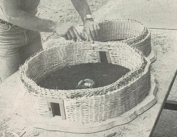
The technique of wattling involves planting upright wooden staves in the ground, then weaving flexible branches, usually of willow or hazel, between them, to create a wickerwork wall or fence.
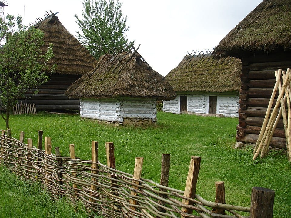
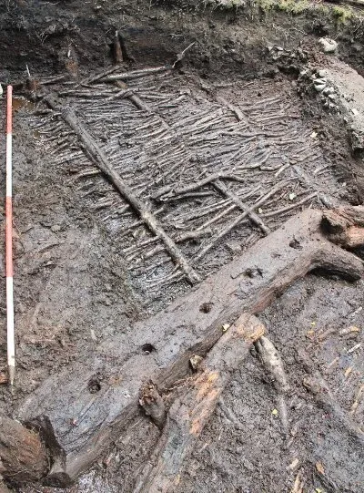
There’s ample evidence of various kinds that it was used as a construction material at early church sites in Britain and Ireland. In Book II, chapter 3 of the Life of St Columba, written around 700, for example, Iona monks collect willow stems to build a wattle guest-house on the island.
Thrillingly, in 2017 a team from the University of Glasgow discovered archaeological evidence of a wattle and timber building on Tòrr an Aba on Iona, exactly where the Life of St Columba says that the saint had his writing hut.
Radiocarbon dates obtained from charred hazel rods indicated that the wattle hut had been built between 540 and 650, a span that contains the whole of Columba’s time on Iona (c.565–597), making it highly likely that this was indeed where he would retreat to write.
In his 2010 book Churches in Early Medieval Ireland, the archaeologist Tómas Ó Carragáin noted several other references to wattle-built church buildings in early sources. These include Gregory of Tours (d. 594), whose History of the Franks mentions a wattle church built on the ramparts of Paris, and the Irish Life of Mochuta, which claims that Columba planted the first three rods of Mochuta’s wattle church at Rahan in Co. Offaly.
Additional place-name evidence for wattle-built churches
Ó Carragáin also noted other place-name evidence supporting the idea that some early churches were constructed of wattle. Kilclief in Co. Down, for example, is in origin Cill-Chléithe, ‘wattle church’.
My research suggests that the same meaning may be present in Boleskine, on the east bank of Loch Ness (below).
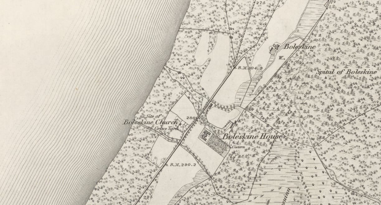
The toponymist Alexander Macbain identified this name as Gaelic both-fhlescáin, ‘withy-hut’, from flesc, ‘rod’.[6] However, Simon Taylor has argued that in Pictland, both can sometimes mean ‘church’ rather than ‘hut’, especially when the both- place was the name of a medieval parish.[7]
That’s certainly true of Boleskine, which was a parish before its 1618 merger with Abertarff.[8] If both does refer to a church here, it would make Boleskine an exact cognate of Kilclief, ‘wattle-church’.
The long preservation of ecclesiastical bangor names
Over time, it seems that place-names like Bangor, Kilclief and Boleskine came to refer to the space or area originally enclosed by wattle, rather than the wattle wall or fence itself. Attached to the overall ecclesiastical site, these names survived for centuries after the original wattling had burned or rotted away.
This transfer of meaning from 'enclosing fence' to 'whole site' was explained very lucidly by Sir Ifor Williams, when discussing how a name meaning ‘plaited fence’ could come to be applied to the great monastery of Bangor in Caernarfonshire:
Around [St] Deiniol’s llan at Bangor there must have been a plaited hedge, and it was a particularly big one. Within it was the cell or church, and numerous huts for the monks or disciples. I suggest that bangor acquired as a secondary meaning this consecrated land with the hedge, i.e. the llog or locus of the monks.[9]
The co-location of bangor with llog/locus here is particularly interesting, since the place-names Banchor and Logie occur upstream and downstream respectively of the Princess Stone at my focus site on the Findhorn (see map above). And on the Don, Edinbanchory is also located in a district called the Land of Logie (below).
Not just an ecclesiastical building material
The fact that wattle fencing was a commonly-used material for church enclosures would explain the strong correlation in Scotland between banchor place-names and early church sites.
But it could also explain why not every banchor place has an associated ecclesiastical site. Wattle was used for other things too: Scotland’s Iron Age crannogs (artificial lake dwellings) had wattle-built walls, as did homesteads like those at Deer Park Farms in Co. Antrim. (Thanks to Dr Murray Cook for this info!) Wattle was also used to construct medieval fish-traps.
Some of these non-ecclesiastical uses may explain the banchor names in Scotland that don’t have an obvious connection with an early church. The lochs named banchor and banchoran may have been known for having wattle fish-traps, for example, while places like Banchory in Fife and Banchory on the Earn may have been named for secular wattle-constructed buildings.
Banchor and the early church in Northern Pictland
If that’s the case, then perhaps there's something interesting in the distribution of banchor places that do seem to be associated with early church sites.
As I mentioned earlier, these all lie north of the Mounth, from Banchor on the Calder in Inverness-shire to Banchory-Devenick near the mouth of the Dee in Kincardineshire.
Is it possible that wattle enclosures were a feature of (some) northern Pictish churches, while the southern Picts used different building materials – like turf, timber, or even stone?
The ecclesiastical nature of these northern banchors may also provide a clue to the location of Watson’s lost ‘Benchar’ on the River Ness.
His ‘river bend’ interpretation led him to place it just downstream of Dochgarroch, where the river bends northwards. However, the nineteenth-century Inverness historian Charles Fraser-Mackintosh separately identified a seventeenth-century barony named ‘Beandcher’, which comprised the whole western Ness-side area from Dunain on the River Ness down to Abriachan on Loch Ness.[10]
Coincidentally, this was also the extent of the medieval parish of Bona, prior to its merger with Inverness parish in 1618.[11] It had a church (which may or may not have been the parish church) located centrally at Kirkton, on the western bank of Loch Dochfour between Loch Ness and the River Ness (below).
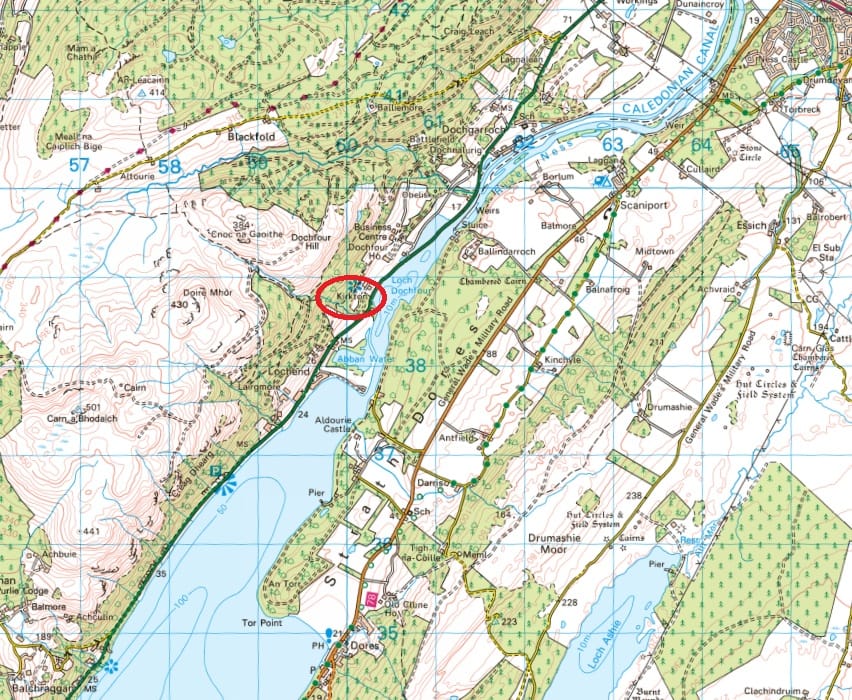
As I noted at the end of my last blog, Kirkton of Bona bears some hallmarks of an early church site, including multiple dedications to Curetán, who was bishop of Ross around the turn of the eighth century. Sitting at the centre of the later barony of Beandchar, it may be the original banchor that gave rise to the place-name.
I also suggested that we may see a glimpse of the late seventh-century church settlement at Bona in the Life of St Columba. In Book I, chapter 34, Columba directs his monks to move their boat to a nearer hut, to protect it from a ‘hostile pursuer’ intent on setting fire to the settlement. In my blog, I proposed that this episode takes place on the bank of Loch Dochfour, exactly where Kirkton is now.
It’s quite something to think that the huts described by Adomnán, perhaps constructed from wattle like Columba’s writing hut on Iona, may have constituted Watson’s lost Ness-side banchor.
Conclusion: a Brittonic word for wattle-constructed sites
My conclusion from all this is that there are good reasons to consider that banchor place-names in Scotland come from a Brittonic/Pictish word meaning ‘wattle fence’, rather than a Gaelic word meaning ‘horn-cast’ or ‘collection of peaks’.
As a building technique, wattle was used at numerous early church sites, and the evidence I’ve considered in this blog suggests that it may have been particularly prevalent in the northern Pictish church.
However, wattle was used at secular sites too, explaining why banchor place-names aren’t just found at early church sites. The long-lived nature of church sites has ensured the survival of many ecclesiastical banchor names, while the more ephemeral nature of secular sites means that many other banchor names have likely been lost.
Banchor isn’t an exclusively ecclesiastical place-name element, in other words, but it has survived best at church sites, creating the misleading impression that it is.
Thank you for reading, and, as ever, I’d be delighted to hear any thoughts you may have.
[1] Robert Thomson, The Natural History of a Highland Parish: Ardclach, Nairnshire (Nairn, 1900), 205.
[2] Thomas Owen Clancy, ‘Logie: An ecclesiastical place-name element in eastern Scotland’, Journal of Scottish Name Studies 10 (2016), 25–88.
[3] Alexander Forbes, ‘”The banchor of Kildrummy”: a forgotten religious landscape?’, in Cultural Landscapes of North-east Scotland: Collaborative Research in History and Archaeology, edited by Colin Shepherd (Oxford and Philadelphia, 2025), 85-86.
[4] William J. Watson, The Celtic Place-Names of Scotland (London, 1926), 481–482.
[5] Bedwyr Lewis Jones, ‘Why Bangor?’, Ainm 5 (1991), 58–65.
[6] Alexander Macbain, Place-Names of the Highlands and Islands of Scotland (Stirling, 1922), 141.
[7] Simon Taylor, ‘Place-names and the early church in eastern Scotland’, in Scotland in Dark-Age Britain, edited by Barbara Crawford (Scottish Cultural Press, 1996), 95–98.
[8] Alasdair Ross, Land Assessment and Lordship in Medieval Northern Scotland (Turnhout, 2015), 204–205.
[9] Cited in Bedwyr Lewis Jones, ‘Why Bangor?’, 61.
[10] Charles Fraser-Mackintosh, Antiquarian Notes, Historical, Genealogical and Social, Second Series (Inverness, 1897), 31–32.
[11] Alasdair Ross, Land Assessment and Lordship in Medieval Northern Scotland (Turnhout, 2015), 213–214.